Publications
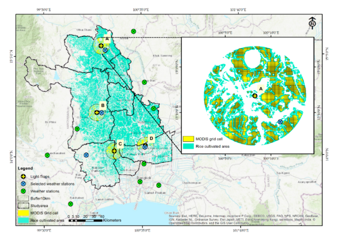
Predicting Rice Pest Population Occurrence with Satellite-Derived Crop Phenology, Ground Meteorological Observation, and Machine Learning: A Case Study for the Central Plain of Thailand,Sukij Skawsang , Masahiko Nagai. In Applied Science.
Damage Assessment Using ALOS-2/PALSAR-2 for the 2018 Earthquake in Palu, Sulawesi, Indonesia., Nopphawan Tamkuan, Masahiko Nagai , The 40th Asian Conference on Remote Sensing (ACRS 2019). Daejeon, Korea.
Sentinel-1A Analysis for Damage Assessment: A Case Study of Kumamoto Earthquake in 2016, Nopphawan Tamkuan, Masahiko Nagai , International Journal of Science and Technology, 2019.
Apply Deep Learning Techniques on Classification of Single-band SAR Satellite Images, Sirirattanapol C, Tamkuan N, Nagai M. , Springer Geography, 2018.
- Geography and Geoinformatics for Sustainable Development - Proceedings of the International Conference on Geography and Geoinformatics for Sustainable Development 2018 (ICGGS)" in Springer Geography Series.
- Source code : Contact to the authors
Access to Paper
Additional Materials
Agent-Based Modeling of Taxi Behavior Simulation with Probe Vehicle Data , Saurav Ranjit, Apichon Witayangkurn, Masahiko Nagai, Ryosuke Shibasaki, ISPRS Int. J. Geo-Inf. 2018, 7(5), 177 (2018), https://doi.org/10.3390/ijgi7050177
A Taxi Zoning Analysis Using Large‐Scale Probe Data: A Case Study for Metropolitan Bangkok , Apantri Peungnumsai, Apichon Witayangkurn, Masahiko Nagai, Hiroyuki Miyazaki, The Review of Socionetwork Strategies(2018).https://doi.org/10.3390/ijgi7050177
Bangkok Taxi Service Behavior Analysis using Taxi Probe Data and Questionnaire Survey , A. Peungnumsai, A. Witayangkurn, M. Nagai, A. Arai, S. Ranjit, B. R. Ghimire, MISNC '17 Proceedings of the 4th Multidisciplinary International Social Networks Conference, Article No. 14, 2017.
An Improved Risk Assessment of Tsunami Inundation Based on Geospatial and Local Knowledge for Sustainable Development , Ni Made Pertiwi Jaya, Fusanori Miura, Masahiko Nagai, Mauricio Reyes Gallardo, International Journal of Sustainable Future for Human Security, J-SustaiN Vol. 1 00 (2017).
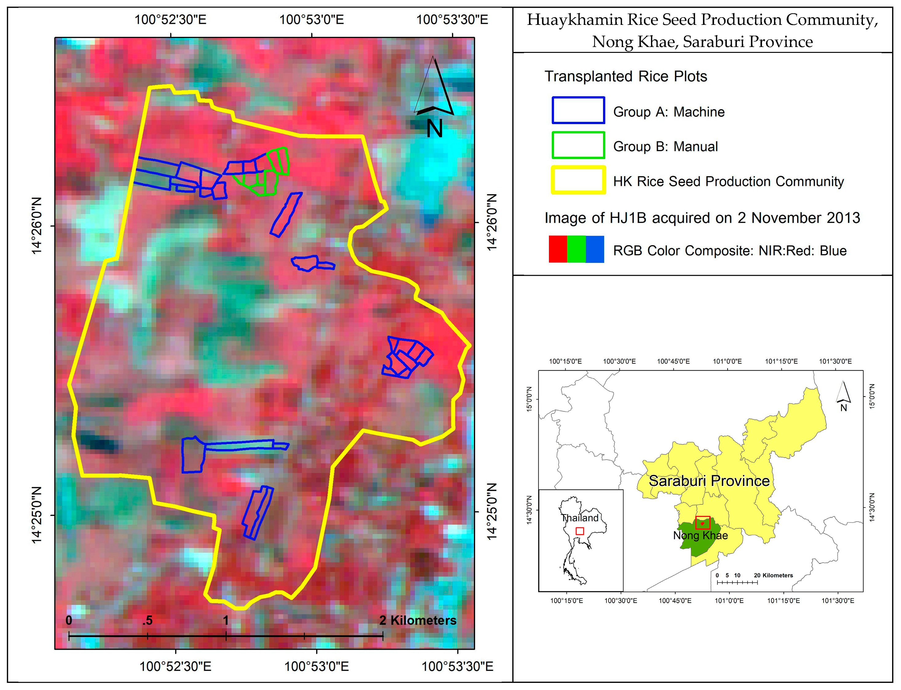
Forecasting Transplanted Rice Yield at the Farm Scale Using Moderate-Resolution Satellite Imagery and the AquaCrop Model: A Case Study of a Rice Seed Production Community in Thailand, Kulapramote Prathumchai, Masahiko Nagai, Nitin K. Tripathi, Nophea Sasaki, ISPRS Int. J. Geo-Inf. 2018.
Large Scale Mobility Analysis: Extracting Significant Places Using Hadoop/Hive and Spatial Processing, Apichon Witayangkurn, Teerayut Horanont, Masahiko Nagai, Ryosuke Shibasaki, International Conference on Knowledge, Information, and Creativity Support Systems, KICSS 2015: Recent Advances and Future Prospects in Knowledge, Information and Creativity Support Systems pp 205-219.
Mapping of Shorea robusta Forest Using Time Series MODIS Data, Bhoj Raj Ghimire, Masahiko Nagai, Nitin Kumar Tripathi, Apichon Witayangkurn, Bhogendra Mishara, Nophea Sasaki, Forests 2017, 8(10), 384.
- Mapping of Shorea robusta Forest Using Time Series MODIS Data
Access the paper
Human mobility analysis for extracting local interactions under rapid socio-economic transformation in Dawei, Myanmar, Satomi Kimijima, Masahiko Nagai, Sustainability 2017.
Classifying building occupancy using building laws and geospatial information: A case study in Bangkok, Chomchanok Arunplod, Masahiko Nagai, Kiyoshi Honda, Pennung Warnitchai, International Journal of Disaster Risk Reduction, DOI: 10.1016/j.ijdrr.2017.07.006, 24 July 2017.

Fusion of Multi-Temporal Interferometric Coherence and Optical Image Data for the 2016 Kumamoto Earthquake Damage Assessment, Nopphawan Tamkuan and Masahiko Nagai, ISPRS Int. J. Geo-Inf. 2017, 6(7), 188; doi:10.3390/ijgi6070188, 22 June 2017.
農業情報の相互流通性を支援するためのオントロジー構築ツールの開発, 長井正彦, 大平亘, 小野雅史, 柴崎亮介, 吉田智一, 瀬下隆, 農業情報研究, Vol. 26 (2017) No. 2 p. 27-33.
- 農業情報の相互流通性を支援するためのオントロジー構築ツールの開発
Access the paper
Perception of Risk and Coping Capacity: A Study in Jiadhal Basin, India
, Arnob Bormudoi, Masahiko Nagai, International Journal of Disaster Risk Reduction, Volume 21, March 2017, Pages 376–383.

Simulation of GNSS Availability in Urban Environments Using a Panoramic Image Dataset
, Sakpod Tongleamnak and Masahiko Nagai, International Journal of Navigation and Observation, Volume 2017 (2017).
Exploring Land Use and Land Cover of Geotagged Social-Sensing Images Using Naive Bayes Classifier
, Asamaporn Sitthi, Masahiko Nagai, Matthew Dailey, Sarawut Ninsawat, Sustainability 2016.
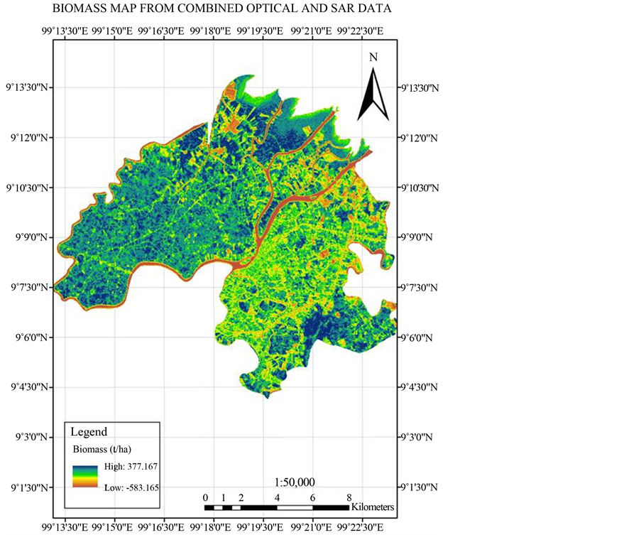
Above Ground Biomass Assessment from Combined Optical and SAR Remote Sensing Data in Surat Thani Province, Thailand
, Kilaparthi Kiran Kumar, Masahiko Nagai, Apichon Witayangkurn, Kunnaree Kritiyutanant, Shinichi Nakamura, Journal of Geographic Information System, 2016.
Modeling Urban Expansion in Bangkok Metropolitan Region Using Demographic–Economic Data through Cellular Automata-Markov Chain and Multi-Layer Perceptron-Markov Chain Models
, Chudech Losiri, Masahiko Nagai, Sarawut Ninsawat and Rajendra P. Shrestha, Sustainability 2016.
Spatial interrelationships of quality of life with land use/land cover, demography and urbanization
, Saad Bhatti, Nitin Kumar Tripathi, Masahiko Nagai, Vilas Nitivattananon, Social Indicators Research, DOI: 10.1007/s11205-016-1336-z, April 2016.

A remote-sensing-based vegetative technique for flood hazard mitigation of Jiadhal basin, India
, Arnob BORMUDOI, Masahiko NAGAI, Natural Hazards, DOI 10.1007/s11069-016-2321-1, 13 April 2016.

Reviews of Geospatial Information Technology and Collaborative Data Delivery for Disaster Risk Management
, Hiroyuki MIYAZAKI, Masahiko NAGAI, Ryosuke SHIBASAKI, ISPRS Int. J. Geo-Inf. 2015, 4, 1936-1964. doi:10.3390/ijgi4041936, September 2015.
Tsunami inundation damping performance of mangrove based on two-dimensional numerical simulation
, Wataru OHIRA, Kiyoshi HONDA, Masahiko NAGAI, IEEE Geoscience and Remote Sensing Society (IGARSS 2015), July 2015.
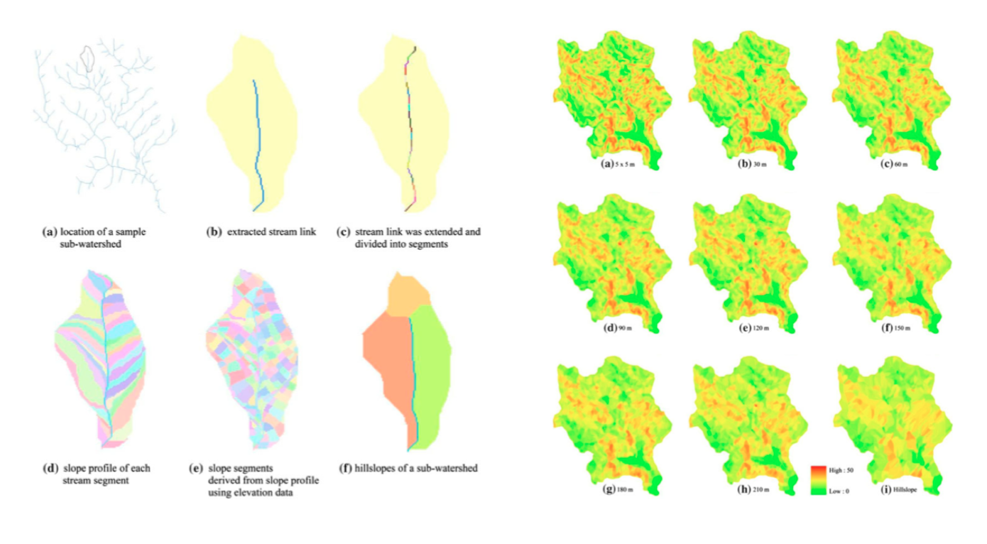
Reducing hillslope size in digital elevation models at various scales and the effects on slope gradient estimation
, Chatchai TANTASIRIN, Masahiko NAGAI, Taravudh TIPDECHO, Nitin K. TRIPATHI, Geocarto International, DOI:10.1080/10106049.2015.1004133, February 2015.
PREDICTING THE POTENTIAL HABITAT AND DISTRIBUTION OF WESTERN TRAGOPAN (TRAGOPAN MELANOCEPHALUS) IN SELECTED AREAS OF AJ & K, PAKISTAN: A MAXENT MODELING APPROACH
, H.Ali, U.Akram, S.Abbas, M.S.Ahmed, F.M.Qamer, B.Khan, M.N.Awan, Z.Ali, A.A.Chaudhry,A.Saghir, M.Nagai, Journal of Animal and Plant Sciences 25(3), ISSN: 1018-7081, January 2015.

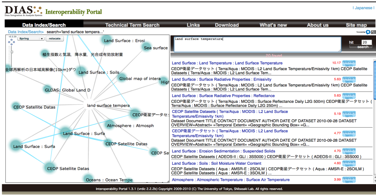
Earth Observation Data Interoperability Arrangement with Vocabulary Registry
, Masahiko NAGAI, Ashik RAJBHANDARI, Masafumi ONO, Ryosuke SHIBASKI, Information Search, Integration, and Personalization Communications in Computer and Information Science, Volume 421, pp. 128-136, June 2014.
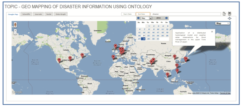
Integration of Disaster Information with Satellite Imagery Using Ontology
, Ashik RAJBHNADARI, Masahiko NAGAI, Masafumi ONO, Ryosuke SHIBASAKI, TRANSACTIONS OF THE JAPAN SOCIETY FOR AERONAUTICAL AND SPACE SCIENCES, AEROSPACE TECHNOLOGY JAPAN Vol. 12(2014) No. ists29, ONLINE ISSN: 1884-0485, June 2014.
Carbon Stock Assessment Using Remote Sensing and Forest Inventory Data in Savannakhet, Lao PDR
, Phutchard VICHARNAKORN, Rajendra P. SHRESTHA, Masahiko NAGAI, Abdul P. SALAM, Somboon KIRATIPRAYOON, Remote Sensing 2014, vol.6, issue 6, 5452-5479; doi:10.3390/rs6065452, June 2014.
Effect of sea level rise in the validation of geopotential/geoid models in Metro Manila, Philippines
, R. B. REYES, M. NAGAI, Y. KAMIYA, T. TIPDECHO, S. NINSAWAT, Survey Review, Survey Review Ltd, Print ISSN: 0039-6265|Online ISSN: 1752-2706, DOI: http://dx.doi.org/10.1179/1752270614Y.0000000102, May 2014.
Discovering Repetitive Patterns in Facade Images using a RANSAC-Style Algorithm
, Kumpee TEERAVECH, Masahiko NAGAI, Kiyoshi HONDA, Matthew DAILEY, ISPRS Journal of Photogrammetry and Remote Sensing, ISSN: 0924-2716, 10.1016/j.isprsjprs.2014.02.018, March 2014.

Influence of surface height variance on distribution of ground control points
, Sudniran PHETCHARAT, Masahiko NAGAI, Taravudh TIPDECHO, Journal of Applied Remote Sensing vol. 8, Issue 1, doi:10.1117/1.JRS.8.083684, January 2014.
The development of a local geoid model (Metro Manila, Philippines) using LSMSA (Least Squares Modification of the Stokes' Formula with Additive Corrections)
, Rosalie B. REYES, Masahiko NAGAI, Yoshikazu KAMIYA, Taravudh TIPDECHO, Sarawut NINSAWAT, The Institute of Electronics Information and Communication Engineers (IEICE) Technical Report, vol. 113, no. 335, SANE2013-79, pp. 47-52, December 2013.
Japanese Encephalitis Risk Zone Mapping Using Remote Sensing Data: A Case Study of Mid and Far-Western Part of Nepal
, Bhogendra MISHRA, Bhoj Raj GHIMIRE, Diwakar BARAL, Yogendra MISHRA, Masahiko NAGAI, Journal of Remote Sensing & GIS, Volume 4, Issue 2, pp.47-55, ISSN: 2230 -7990, July 2013.

Extraction of Mangrove Biophysical Parameters Using Airborne LiDAR
, Wasinee WANNASIRI, Masahiko NAGAI, Kiyoshi HONDA, Phisan SANTITAMNONT, Poonsak MIPHOKASAP, Remote Sensing, vol. 5, issue 4, pp. 1787-1808, April 2013.
- Extraction of Mangrove Biophysical Parameters Using Airborne LiDAR
Access the paper
Crowdsourcing for urban area mapping
, Hiroyuki MIYAZAKI, Satomi KIMIJIMA, Masahiko NAGAI, Koki IWAO, Ryosuke SHIBASAKI, Asia Geospatial Digest, February 2013
- Crowdsourcing for urban area mapping
Access the paper
地球観測データ相互流通のためのデータモデルレジストリの開発
, 長井正彦, 小野雅史, 柴崎亮介, 坂路和也, 岡田泰征, GIS 理論と応用(Theory and Applications of GIS), Vol.20, No.2, pp.71-81, 2012年12月.
- 地球観測データ相互流通のためのデータモデルレジストリの開発
Access the paper
Role and Opportunity for Foreign Investment and Its Risks for Rural Development in Laos
, Satomi KIMIJIMA, Masahiko NAGAI, IJERD – International Journal of Environmental and Rural Development, Volume 3 Number 2, 150-155, October 2012.
Mangrove stilt root morphology modeling for estimating hydraulic drag in tsunami inundation simulation
,Wataru OHIRA, Kiyoshi HONDA, Masahiko NAGAI, Anuchit RATANASUWAN, Springer-Verlag Berlin Heidelberg, DOI: 10.1007/s00468-012-0782-8, September 2012.
EARTH OBSERVATION DATA INTEROPERABILITY ARRANGEMENT WITH ONTOLOGY REGISTRY
, Masahiko NAGAI, Masafumi ONO, Ryosuke SHIBASAKI, ISPRS Annals – Volume I-2, 2012, pp.235-239, August 2012.

Estimating Canopy Nitrogen Concentration in Sugarcane Using Field Imaging Spectroscopy
, Poonsak MIPHOKASAP, Kiyoshi HONDA, Chaichoke VAIPHASA, Marc SOURIS, Masahiko NAGAI, Remote Sensing, 4(6), 1651-1670; doi:10.3390/rs4061651, June 2012.
UAV-Based Sensor Web Monitoring System
, Masahiko NAGAI, Apichon WITAYAGKURN, Kiyoshi HONDA, Ryosuke SHIBASAKI, International Journal of Navigation and Observation, Volume 2012 (2012), Article ID 858792, March 2012.

- UAV-Based Sensor Web Monitoring System
Access the paper
Real-time monitoring system using unmanned aerial vehicle integrated with sensor observation service
, Witayangkurn, A., Nagai, M., Honda, K., Dailey, M., Shibasaki, R., International Archives of the Photogrammetry, Remote Sensing and Spatial Information Sciences - ISPRS Archives.
Interoperability Arrangement For Remote Sensing Data
, Masahiko NAGAI, Masafumi ONO, Ryosuke SHIBASAKI, Asian Journal of GEOINFORMATICS, Volume 9 Number 3 September 2009, ISSN 1513-6728, pp.15-19, September 2009.
- Interoperability Arrangement For Remote Sensing Data
Access the paper
無人ヘリコプターによる河川環境モニタリング手法の開発
, 長井正彦, 柴崎亮介, アーメッド アーメッド, 水文・水資源学会誌 (J. Japan Soc. Hydrol. and Water Resour.), Vol.2, Nov, pp401-408, 2009年9月.
- 無人ヘリコプターによる河川環境モニタリング手法の開発
Access the paper
A Framework of Collective Intelligence for Building Virtual Agriculture Knowledge Repository and Service
, Masahiko NAGAI, Naiyana SAHAVECHAPHAN, Vasuthep KHUNTHONG, Asanee KAWTRAKUL, and Ryosuke SHIBASAKI, 7th World Congress on Computers in Agriculture Conference Proceedings, Reno, Nevada, 711P0409e.(doi:10.13031/2013.29042) , June 2009.
地球観測データのためのリモートセンシングオントロジーの構築
, 長井正彦, 小野雅史, 柴崎亮介, 写真測量とリモートセンシング (Journal of the Japan Society of Photogrammetry and Remote Sensing), Vol.48, No.1, ISSN 0285-5844, pp.2000, 2009年3月.
- 地球観測データのためのリモートセンシングオントロジーの構築
Access the paper
UAV-Borne 3-D Mapping System by Multisensor Integration
, Masahiko NAGAI, Tianen CHEN, Ryosuke SHIBASAKI, Hideo KUMAGAI, Afzal AHMED, Geoscience and Remote Sensing, IEEE Transactions on Volume 47, Issue 3, ISSN 0196-2892, pp701-708 Digital Object Identifier 10.1109/TGRS.2008.2010314, March 2009.
- UAV-Borne 3-D Mapping System by Multisensor Integration
Access the paper
Interoperability for Global Observation Data by Ontological Information
, Masahiko NAGAI, Masafumi ONO, Ryosuke SHIBASAKI, TSINGHUA SCIENCE AND TECHNOLOGY, Volume 13, Number S1, ISSN 1007-0214 54/67, pp336-342, October 2008.
地球観測データ統合にむけた地名辞典構築に関する研究
, 長井正彦, 明海大学不動産学部論集2008, N0.16, pp69-76, 2008年3月.
- 地球観測データ統合にむけた地名辞典構築に関する研究
Access the paper
Acquisition of 3D Spatial Data for Indoor Environment by Integrating Laser Scanner and CCD Sensor with IMU
, Yong-Cheol SUH, Masahiko NAGAI, Journal of the Korean Association of Geographic Information Studies. 01/2007; 10(1), pp.1-9, January 2007.

Robust Trajectory Tracking by Combining GPS/IMU and Continual CCD Images
, Masahiko NAGAI, Ryosuke SHIBASAKI, Proceedings of the Twenty-Fifth International Symposium On Space Technology and Science Kanazawa 2006, Japan Society for Aeronautical and Space Sciences and Organizing Committee of the 25th ISTS, pp1189-1194, December 2006.
Application of 3D Laser Mapping and HEM using UAV for the Landslide Investigation of the Mid Niigata Prefecture Earthquake
, Fumiya NAKAYAMA, Masahiko NAGAI, Seiichiro KURODA, Youichi YUUKI and Koyo HATAKEYAMA, The 8th SEGJ International Symposium - Imaging and Interpretation -, Kyoto University, Japan, pp.1-4.ISBN:978-4-938493-09-7, doi:10.1190/segj082006-001.5, November 2006.
A Novel Vehicle-Borne System for Traffic Signs/Signals extraction Using Laser Range Scanners and CCD Images
, YuZhong CHEN, Huijing ZHAO, Masahiko NAGAI, Xiaowei SHAO, Ryosuke SHIBASAKI, ITS World Congress, London, United Kingdom, October 2006.
無人ヘリコプターを用いた新潟県中越地震による農地地すべり調査
, 長井正彦, 柴崎亮介, 黒田清一郎, 結城洋一, 応用測量論文集 (Journal of Applied Survey Technology), JAST Vol.17, pp.77-85, 2006年7月.
- 無人ヘリコプターを用いた新潟県中越地震による農地地すべり調査
Access the paper
3D Data Acquisition in an Indoor Environment by Integrating Laser scanner and CCD Sensor with IMU
, Masahiko NAGAI, Yongcheol SUH, Tianen CHEN, Hideo KUMAGAI, Ryosuke SHIBASAKI, Asian Journal of GEOINFORMATICS, Volume 6 Number 3 July 2006, pp.1-7, July 2006.
センサ統合による無人ヘリコプター搭載型マッピングシステム
, 長井正彦, 柴崎亮介, 陳天恩, 熊谷秀夫, 水上慎太郎, 写真測量とリモートセンシング (Journal of the Japan Society of Photogrammetry and Remote Sensing), Vol.44, No.6, ISSN 0285-5844, pp.58-67, 2006年1月.
- センサ統合による無人ヘリコプター搭載型マッピングシステム
Access the paper
Semi-Real-Time Direct Geo-Referencing of Integrated Laser Scanning and CCD Sensor by Combining GPS/IMU and Bundle Block Adjustment of CCD Images
, Masahiko NAGAI, Ryosuke SHIBASAKI, Hideo KUMAGAI, Dinesh MANANDHAR, Huijing ZHAO, Proceedings of the 17th International Technical Meeting of the Satellite Division of The Institute of Navigation (ION GNSS 2004), Long Beach, California U.S.A., pp253-260, September 2004.
Real-Time Volcano Activity Mapping Using Ground-Based Digital Imagery
, Kiyoshi HONDA, Masahiko NAGAI, ISPRS Journal of Photogrammetry and Remote Sensing, vol 57/1-2 pp.159-168, November 2002.
